| Cantavir | |
|---|---|
| Kongaavkaarn | |
|
| |
| Area | 562,662 U (1st) |
| Population | 31,800,000 |
| Denonym | Cantaviran |
| Capital City | Flushink |
| Largest City | Flushink |
| Empire | Central Union |
| Independence Date | E2Y508[2133] |
| Currency | CU Krenta (Ԇ) |
| Current President | Hayeda Vultroth |
| Territories | [territories] |

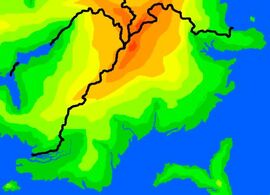
Cantavir shown in a very simple elevation map.

Cantavir as seen from space.
Cantavir is one of the 17 countries on Mundu and is part of the Central Union and the WPP . It borders Siovok to the north, Vosprym to the west, and Ivanyc to the north-west. It is the biggest country on Mundu.
Geography[]
Cantavir is overall a hilly country, with the Spine of the World to the north-west. Along the coast is a dense forest consisting of very tall and wide trees. Further inland is more forest, but much less dense, and in some areas it is just vast green plains. In the north of Cantavir it more open with sparse forest and plains, leading into some tundra. Cantavir also has claim to an island south of its most southern coastline. This island is very dry compared to the mainland and for a while was disputed with Siremyn.
History[]
Cantavir became a country soon after Ivanyc , for the same reasons. It gained independance from Jaffretti about 4600 years ago, under the name Copinrym. A few centuries later, it's name changed to Cantavir when the then current language, Cymriyl-Kamyt, went extinct. To take its place was Drevni, which stayed as the language that all country names are written in. Cantavir contributed in two theatres in the War of the Sea (Cantavir Sea and Samoor Sea), and this killed off its population greatly, and reduced its force, but the country managed to keep its borders. Later, in the War of the Races, Cantavir was again at the center of battle, which ruined what it had built up to that point.
Population[]
The population of Cantavir is mainly human, as it is the perfect climate for them. In the north is some norskemour population.